 |
|
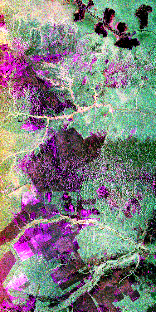
CTop-This radar image shows the dramatic landscape in the Phang Hoei Range of north central Thailand, about
40 kilometers (25 miles) northeast of the city of Lom Sak. The plateau, shown in green to the left of center, is
the area of Phu Kradung National Park. The area shown is 38 by 50 kilometers (24 by 31 miles) and is centered at
16.96 degrees north latitude, 101.67 degrees east longitude. Colors are assigned to different radar frequencies
and polarizations as follows: red is L-band horizontally transmitted and horizontally received; green is L- band
horizontally transmitted and vertically received; blue is C- band horizontally transmitted and vertically received.
The image was acquired by the Spaceborne Imaging Radar-C/X-band Synthetic Aperture (SIR-C/X-SAR) imaging radar
on October 3, 1994, when it flew aboard the space shuttle Endeavour
SIR-C/X-SAR is a joint mission of the U.S./German and Italian space agencies..
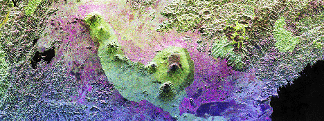
Page 210: This is a false-color radar image of Central Africa, showing the Virunga Volcano chain along the borders
of Rwanda, Zaire and Uganda. This area is home to the endangered mountain gorillas. This C- and L-band image was
acquired on April 12, 1994, on orbit 58 of space shuttle Endeavour by the Spaceborne Imaging Radar-C/X-band Synthetic
Aperture Radar (SIR-C/X-SAR). The area is centered at about 1.75 degrees south latitude and 29.5 degrees east longitude.
The image covers an area 58 kilometers by 178 kilometers (48
miles by 178 miles). The false-color composite is created by displaying the L-band HH return in red, the L-band
HV return in green and the C-band HH return in blue. The dark area in the bottom of the image is Lake Kivu, which
forms the border between Zaire (to the left) and Rwanda (to the right). The large volcano in the center of the
image is Mt. Karisimbi (4,500 meters or 14,800 feet). This radar image highlights subtle differences in the vegetation
and volcanic flows of the region. The faint lines shown in the purple regions are
believed to be the result of agriculture terracing by the people who live in the region. The vegetation types are
an important factor in the habitat of the endangered mountain gorillas. Researchers at Rutgers University in New
Jersey and the Dian Fossey Gorilla Fund in London will use this data to produce vegetation maps of the area to
aid in their study of the remaining 650 gorillas in the region.
Check out The Virunga Mountain Gorilla remote sensing website
for more.
|
|
|