Mongabay.com is considered a leading source of information on tropical forests by some of the world's top ecologists and conservationists. BIOME CHARTS

CHART: Peatland loss in Indonesia and Malaysia


Chart: Peatland loss in Indonesia and Malaysia
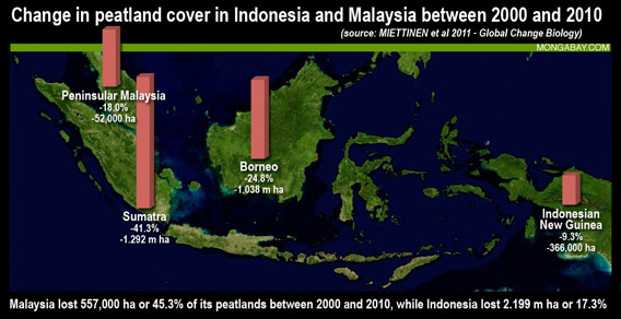
Graph: Change in peatland cover in Indonesia and Malaysia between 2000 and 2010. Background satellite image courtesy of Microsoft/Bing Maps and NASA, design by mongabay.com. Click image to enlarge.

This peat forest cover data is from Miettinen et al 2011


Change in peat cover for Indonesia and Malaysia, 2000-2010


20002010Change 2000–2010
1000 ha%1000 ha%1000 ha%%/yr
Peninsular Malaysia2872.22351.8-52-18.0-2.0
Sumatra31317.218394.2-1292-41.3-5.2
Borneo41825.731444.3-1038-24.8-2.8
Java0.00.00.00.00.00.00.0
Sulawesi0.00.00.00.00.00.00.0
New Guinea633617.0597016.0-366-5.8-0.6
Sabah, Sarawak, and Brunei943438-505-53.6%-5.4%
Kalimantan32392706-533-16.5%-1.6%
Indonesia127406.9105415.7-2199-17.3-1.9
Malaysia12303.76732.0-557-45.3-5.9
Total study area139706.4112145.1-2756-19.7-2.2


CITATION: Jukka Miettinen, Chenghua Shi and Soo Chin Liew. Deforestation rates in insular Southeast Asia between 2000 and 2010. Global Change Biology (2011) 17, 2261–2270, doi: 10.1111/j.1365-2486.2011.02398.x


Other sections

LATIN AMERCA
ASIA GLOBAL MORE DEFORESTATION DATA


what's new | rainforests home | for kids | help | madagascar | search | about | languages | contact

Copyright Rhett Butler 1994-2015

Carbon dioxide (CO2) emissions generated from mongabay.com operations (server, data transfer, travel) are mitigated through an association with Anthrotect,
an organization working with Afro-indigenous and Embera communities to protect forests in Colombia's Darien region.
Anthrotect is protecting the habitat of mongabay's mascot: the scale-crested pygmy tyrant.

"Rainforest" is used interchangeably with "rain forest" on this site. "Jungle" is generally not used.